KidZone Geography - Canadian Provinces
Prince Edward Island, Canada
 Prince Edward Island is the smallest of Canada's ten
provinces. It is an
Atlantic or "Maritime" province. It can be found on the
East Coast of the country, near the Atlantic Ocean.
Prince Edward Island is the smallest of Canada's ten
provinces. It is an
Atlantic or "Maritime" province. It can be found on the
East Coast of the country, near the Atlantic Ocean.
The province joined Confederation on July 1, 1873.
Check out our brief photo tour of PEI if you'd like to see more of the scenery of the province or if you need photos for a school project.
You can find out a lot of interesting information about the province at http://www.gov.pe.ca/
© Leanne Guenther
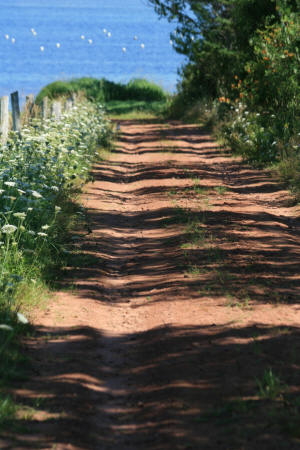
PEI is famous for it's red dirt -- great for growing
potatoes and getting your shoes dirty!
Free Printable Worksheets:
- Prince Edward Island flag worksheet
- Prince Edward Island map and response worksheet
- Prince Edward Island map - Name the Capital City
- Prince Edward Island map - Name the Province
- Prince Edward Island provincial bird with labels worksheet
- Prince Edward Island provincial bird coloring page
- Prince Edward Island provincial flower with labels worksheet
- Prince Edward Island provincial flower coloring page
Free On-Line Activities:
© Leanne Guenther
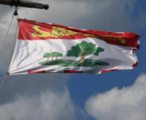
Provincial flag of Prince Edward Island
The Provincial Flag
Prince Edward Island’s flag was adopted on March 24, 1964. It mimics the province's shield, showing an oak tree and three saplings. The Oak is known as the "Oak of England" the saplings represent the three counties of the province: King's, Queen's and Prince.
 The Provincial Flower
The Lady's Slipper was declared Prince Edward Island's provincial flower on April 25, 1947. It is a type of orchid that blooms in late May and June and grows in shady and moist woodlands.

Used with permission. © Robert
McDonald
Thanks to Robert for allowing us to use this picture.
The Provincial Bird
The Blue Jay was made Prince Edward Island's provincial bird in 1977. The birds lay 3 to 7 blue-green eggs each year.
They feed on fruits, nuts, acorns, seeds, insects and the eggs of other birds.